A Discovery Drilling crew drills a borehole on the hillside southeast of the Beach Road landslide area. The work is part of an ongoing study on landslide risk. Max Graham photo.

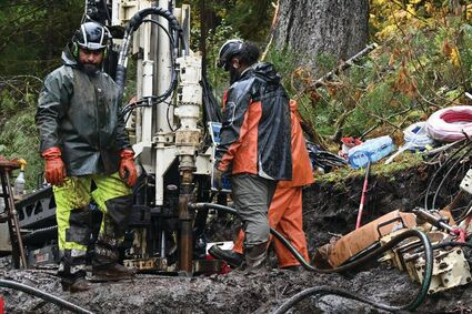
The second and final phase of the Beach Road landslide geotechnical study is almost done.

The technicians drilling boreholes in the slide area hope to finish their work by the end of October. They have been taking core samples and installing underground monitors for more than a month.

Data collected from the boreholes will be included in a report on the stability of the slope above Beach Road that slid in December, killing two residents and destroying homes.

Several properties are in a “red zone”-an area under the December slide crack deemed unsafe to live in-and much of Beach Road remains closed to the public due to uncertainty about the risk of more slides. Through analysis of soil composition and groundwater flow, the study will provide insight into the nature of the December slide, pinpointing where and why the hillside collapsed, and estimating the likelihood of future slides.

Oregon-based Landslide Technology is overseeing the two-phase research. The first phase, a surface reconnaissance, was completed in July.

Operating small rigs slung from one site to the next by helicopter, two crews from Anchorage-based Discovery Drilling had completed seven boreholes as of Tuesday and planned to drill five more. The holes are less than a foot in diameter and vary in depth, from 40 to 125 feet.

“It’s difficult drilling conditions, and we understood that from the get-go. So far the drilling itself is tracking about as we expected,” said Adam Koslofsky, project geologist at Landslide Technology. “The big thing we’re always fighting is weather.”

Koslofsky said he often oversees work on sites next to a water source that are easily accessible by ground. But that’s not the case for this project. The crew needs a helicopter to haul water from Lily Lake and to sling gear across the hillside from one drill site to another.

Wind and rain this week kept the helicopter from flying, so a crew couldn’t get the water needed to operate the drill.

A crew of three drillers takes about two or three days to drill each hole if the weather cooperates. Once they’ve drilled the hole, an engineer lowers a camera into the ground to photograph slope fractures. He also equips each hole with two vibrating wire piezometers to measure groundwater pressure and an inclinometer to detect movement (and its direction) in the hillside. Data from each device can be accessed remotely for analysis.

Landslide Technology’s findings are expected to be published in a report by the end of December, said Travis Eckhoff, technical engineer at the Alaska Department of Transportation, which commissioned the study.

The firm also will provide monitoring updates every two months until next fall.